|
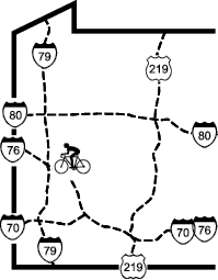
Butler Freeport Community Trail |
one moment while we fetch a trail picture
|
|
|
Butler Freeport Community Trail |
one moment while we fetch a trail picture
|
Write-up last update on
Text version of 18 Jul 2018 based on personal observation while bicycling Butler to Cabot 8/2024 to Dittmer 10/2025Laneville 8/2022, Laneville to Tredway Riverfront Trail 8/2022. Conditions may have changed; you are responsible for your own safety. Oldest segment check 8/2022.
1 Sharrows or Shared Lane Markings. A street marking painted in the travel lane consisting of a bicycle with chevrons above it, to indicate where people should preferably cycle.
2 Sharrows or Shared Lane Markings. A street marking painted in the travel lane consisting of a bicycle with chevrons above it, to indicate where people should preferably cycle.
The last update on date is the last time that we made a change to the writeup.
The Oldest Segment check date" is the date for which we have reliable information on that segment. For shorter trails this probably means the entire trail. For longer trails, we break the trail into segments and ride the trail over several days, which may be some time apart. We also talk to the trail managers, when we know there is development activity in progress.
This website was created via an automated process from the current daft of the book Freewheelingeasy in Western Pennsylvania. As we ride the trails, we are continuously updating the guide book. The amenity information is updated based on data from the Google Map webpages.
| This page brought to you by the book FreeWheeling
Easy in Western Pennsylvania. It covers 32 trail northeast of Pittsburgh. |
Order the book |
If you see any inaccuracies, problems,or have suggestions for additional content please use the comment form on the Freewheeling website https://freewheelingeasy.com/webmaster-feedback/.
Roy and Mary