|
Butler Freeport Community Trail |
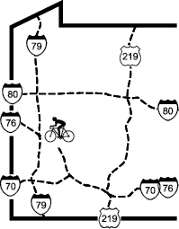
one moment while we fetch a trail picture
|
|
|
Butler Freeport Community Trail |
one moment while we fetch a trail picture
|
| Location | Butler to Laneville in Butler County and Armstrong County | ||
| Trailheads | Father Marinaro Park, Bonniebrook, Dittmer Rd, Sheetz Dr, | ||
| Length, Surface | 21.3 miles total (19.8 crushed limestone, 1.5 paved) | ||
| Character | Uncrowded to busy, wooded, shady, steady gentle grade | ||
| Usage restrictions | No horses, no motorized vehicles | ||
| Amenities | Seasonal chemical toilets, food | ||
| Driving time from Pittsburgh | 0 hours 42 minutes |
The trail is a rail-trail, but as rail-trails go the typical gradient of about 1% is somewhat more noticeable than usual. The general trend of the gradient is uphill from each end of the trail to the middle. Cyclists wanting to ride uphill first, then downhill on the return, can do this by starting at either end.
With the opening of a new bridge in 2015, the entire trail from Father Marinaro Park in Butler to Laneville is open. The trail is finished in crushed limestone with mowed grass edges. Many the road crossings have less-than-ideal sight lines and high-speed traffic, so use caution when crossing.
The trail begins on Kaufman Dr just at the edge of Father Marinaro Park (MP20.5). There is parking for a few cars here, and there is more parking on the other side of the park by the ballfield. The trail begins by crossing a bridge over Coal Run. The first three quarters of a mile are sunny. Then the trail becomes narrower (4 to 6 feet) and mostly shaded, with occasional sunny stretches, running on a bank above Herman road with occasional crossings of minor roads and driveways. Many of these crossings have soft edges or small ditches where they cross the trail.
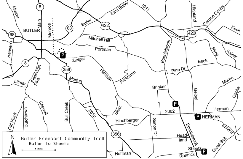
From about MP18 to MP17.5, the trail is on a high embankment above a shooting range. The area is well marked, but trail users should stay on the trail. The trail continues, mostly wooded, to the Bonniebrook Rd crossing (MP16.5). Of all the road crossings this seems to have the most and fastest traffic.
After Bonniebrook the trail widens to 10 to 12 feet wide and the woods give way to farms and the trail passes through several small cuts. A large school building appears below on the right (MP15.7). This is St. Fidelis School. It was founded in 1877 and is now (2018) the Summit Academy for delinquent youth. Just past the school the trail crosses over Herman Rd and emerges in the small community of Herman. The community’s general store, post office, and ticket station still stands in Herman (MP15.6), and new owners have rehabilitated the building for the Derailleur Bike Shop Cafe. A detailed interpretive sign explains the history of the store and its previous owners.
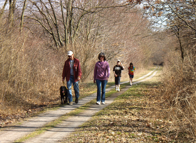
Walking on the trail
The trail then goes past a couple of farms, through some cuts, along an embankment between two lakes, and through the Bonniebrook Golf course (MP15.0) with a clubhouse/restaurant at the top of the hill. The restaurant welcomes bicyclists, but it is uphill about a quarter-mile from the trail.
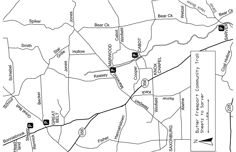
From the golf course to a cut near MP13.6 the trail continues on cuts and fills on top of the ridge. The power line crossing at the south end of the cut at MP13.5 marks the end of the climb from Butler. From Great Belt (MP14.2) to Cabot (MP9.4), there are more signs of development, with small towns, parallel roads, businesses, and farms. The power substation 0.8 miles south of Great Belt was the site of the world’s then-largest oil storage facility; a historical sign provides some information.
Near MP11.5 there are traces of an old industrial site on the west side of the trail. This is the first, and the most conspicuous, of several such ruins. They are part of the processing plants for the Franklin Glass and Ford Glass quarries. Foundations and walls appear on both sides of the trail for the next half-mile or so, and the remnants of two stone or concrete dams are visible in the creek on the northeast side.
The crossing of Winfield Rd in Cabot (MP9.4) is guarded by flashing lights. Just south of Cabot, on the east side of the trail, carbon black was mined for automobile tires. From here to Laneville the trail is mostly in woods with occasional road crossings. Either Little Buffalo Ck or Buffalo Ck is almost always within view or at least within hearing—the trail crosses the Little Buffalo six times between Cabot and Sarver (MP7.3), and as a bonus it also crosses a small unnamed creek. Beaver dams are sometimes visible on the creek. Near MP6.8 the trail passes a lovely home set on a small lake. From Bear Creek Rd (MP5.6) to Monroe Rd (MP4.3) it runs on a bench between the cliff and Little Buffalo Ck. The trail was resurfaced here in 2017.
South of Monroe the trail is on a paved road that was constructed as part of a sewer plant project. This limited access road only goes to the sewer plant and typically does not have any traffic. Not far south of the Monroe trailhead is Winfield Junction (MP4.0), where Little Buffalo Ck joins Buffalo Ck. The junction is named for the railroad junction, as there is no town or road access here. Shortly after the junction but before the sewer plant (MP3.2), the undersides of overhanging rocks show fossils, as well as drill holes left over from railroad construction. Immediately after the sewer plant the trail passes under the high PA28 bridge and the trail surface returns to crushed limestone.
A half-mile past the sewer plant and bridge is a large area of industrial ruins which lie in the flats on the west side of the trail. This is the remnant of the Harbison Brick Co brickworks; it’s private property. Five domed brick kilns baked bricks at a temperature of 2000°; their foundations may be visible from the trail when the leaves are off the trees. Shortly after this area is a handsome dressed-brick culvert. The area once supported numerous clay mines and the area is littered with specialty bricks.
The trail enters Laneville at MP0.8, crosses the gravel parking lot, and picks up as paved trail as it crosses Old Mill Rd. The trail travels through back yards of Laneville, which is the section of Freeport west of Buffalo Ck.
At the entry to the second Laneville parking lot, the trail makes a U-turn to the right/northwest and continues up a steep hill on the road. It travels 350 feet on Main St and takes a sharper U-turn to the left/southwest towards SR356 on Old Pike Rd for 450 feet. At the top of the hill just before PA356 the trail turns left/south on a bike-pedestrian path. At the Laneville-Freeport bridge the trail splits—the left branch goes across Buffalo Ck to Freeport and the straight -ahead branch continues across the Allegheny River to the Tredway Trail (described in the Near Pittsburgh Volume of this guide).
To get to the main part of Freeport, the route crosses the Laneville-Freeport bridge on 2nd St and then turns left/north on Buffalo Av. In about 0.3 miles it enters the main business district and changes its name to Fifth St. Freeport is adding bike lanes and sharrows (shared lane markings) to make bicyclists feel welcome and to become a Trail Town
To get to the Tredway Trail, the route continues straight across 2nd St and goes under the PA356 bridge. After passing under the bridge, the path loops uphill to the right and joins the 8-foot sidewalk on the PA356 bridge across the Allegheny River. Once across the bridge, the trail makes a U-turn to the right/north on River Landing Dr and heads steeply down to the Allegheny River and the Tredway Trail.
Butler Freeport Community Trail - Oldest segment segment check 2022-Aug This page brought to you by the book