|
Butler Freeport Community Trail |
one moment while we fetch a trail picture
|
|
|
Butler Freeport Community Trail |
one moment while we fetch a trail picture
|
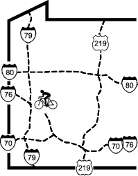
Vicinity: Directions begin at end of the exit ramp from PA28 Exit 17 (marked “Butler-Freeport” where it tees into PA356. To reach this point from Pittsburgh, go northeast on PA28 to Exit 17 (the second Freeport exit). This is about 20 miles northeast of the Highland Park Bridge interchange on PA 28.
Butler Father Marinaro Park (northern) trailhead: Turn right/north on PA356 and go 14.5 miles from PA28 to a “Y”. Turn right/north on Center Rd to stay on PA356. Go 0.8 miles and just before the church turn sharp right/east on Ziegler Av. Go 0.3 miles to the second right and turn right/north on Kaufman Dr. Go 500 feet to trailhead parking on the right, by the bridge. If the lot is full go another 0.3 miles to the baseball parking lot on the left.
Bonniebrook trailhead: Turn right/north on PA356 and go 8.5 miles to Bonniebrook Rd. Bear right/north on Bonniebrook Rd. The trail crosses this road 3.8 miles later. Trailhead parking is on the right, near (but not blocking) the gravel pile.
Dittmer Rd trailhead: Turn right/north on PA356 and go 8.5 miles to Bonniebrook Rd. Bear right/north on Bonniebrook Rd. Continue 3.4 miles and turn right/east on Herman Rd. Go 0.5 miles, cross under the trail and turn right/south on Dittmer Rd. Go 0.1 miles to trail parking on the right and the Derailleur Bike Shop Café on the left.
Sheetz Dr trailhead: Turn right/north on PA356 and go 8.5 miles to Bonniebrook Rd. Bear right/north on Bonniebrook Rd. Continue 2.2 miles and turn right/east on the Sheetz Dr. Go 0.3 miles to the trail.
Great Belt Rd trailhead: Turn right/north on PA356 and go 8.5 miles to Bonniebrook Rd. Bear right/north on Bonniebrook Rd. Continue 1.6 miles and turn right/east on the Great Belt Rd. Go 0.2 miles to the trail parking on the right
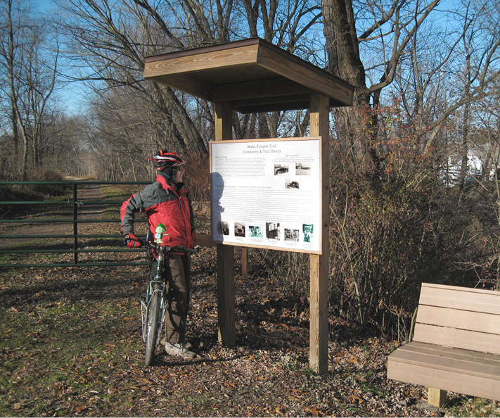
Interpretive sign at Herman
Marwood trailhead: Turn right/north on PA356 and go 7.3 miles to Marwood Rd. Turn right/northeast on Marwood Rd (SR2010). The trail crosses this road 1.1 miles later. Trailhead parking is on the right.
Cabot trailhead: Turn right/north on PA356 and go 6.5 miles to the traffic light at Winfield-Cabot Rd. Turn right/northeast on Winfield-Cabot Rd (SR2010). The trail crosses this road almost a mile later. After crossing the creek and the trail, turn left/northwest on Helmbold Av and then in 500 feet turn left/southwest on Center Av. Trailhead parking is just ahead on the right.
Sarver trailhead: Turn right/north on PA356 and go 3.7 miles to Sarver. Turn right/northeast on Sarver Rd (SR2018) toward Sarver. Go down the hill and along the creek for 0.8 miles. Just after crossing the creek and passing the volunteer fire department, turn left/north into the parking area alongside the trail.
Bear Creek trailhead: Turn right/north on PA356 and go 1.4 miles to Bear Creek Rd. Turn right/northeast on Bear Creek Rd (SR2023); this corner is marked for the Buffalo Township Municipal Building. In 0.4 miles bear right/north to descend the hill 0.4 miles toward Little Buffalo Ck. The road crosses the trail just before the bridge over the creek. There is parking for 6–8 cars near the trail gate.
Monroe trailhead: Turn right/north on PA356 and go about a mile to the traffic light at Monroe Rd. Turn right/east at on Monroe Rd and go 0.8 miles to the bottom of the hill, where it crosses Little Buffalo Ck. After crossing the bridge and passing a driveway, turn right/east into a small parking area. Do not block access to the service road.
Laneville trailhead at Old Mill Rd: Turn left/south on PA356 and go 1.4 miles to the bottom of the hill. At the bottom of the hill, before the 2nd Av Bridge to Freeport, turn left/east on Old Pike Rd and descend. In 350 feet, continue to descend by bearing right/northeast on Main. Continue on Main St for a quarter-mile, then bear right/northeast on Old Mill Rd. Just after the street bends right, cross the trail and park on the left.
Laneville (southern) trailhead under Freeport-Laneville bridge: Turn left/south on PA356 and go 1.4 miles to the bottom of the hill. At the bottom of the hill, before the 2nd Av Bridge which goes into Freeport, turn left/east on Old Pike Rd and descend. In 100 feet, make a sharp U-Turn to the right/south. Continue 400 feet to parking.